Table of Contents
⚡ QUICK INSIGHTS
- Strategic Timing: Align visits with lunar cycles. Bioluminescence (Maldives) and tidal reveals (Ireland) depend entirely on gravitational pulls and moon phases.
- Mineral Anomalies: Purple (California), green (Hawaii), and pink (Bahamas) sands are geological rarities. Capturing them accurately requires specific optical gear (circular polarisers).
- Ecological Limits: Sites like Maya Bay enforce merciless daily visitor caps for coral rehabilitation. Advance digital booking is a non-negotiable operational baseline.
- Mobility Context: Premium coasts often lack paved access, demanding 2- to 3-kilometre treks across uneven, jagged, or hyper-saline terrain.
The air at the edge of the world rarely smells of salt alone. It carries the heavy, metallic tang of ancient basalt, the sweet decay of tropical flora, and the electric ozone of crashing surf. To stand where the land surrenders to the ocean is to experience geographic hypnosis. The relentless noise of modernity is swallowed by the rhythm of the tides.
Yet, the reality of global travel is high-friction. It’s 15:00, your feet are aching, the coastal glare is blinding, and sheer crowd density triggers sensory overload. To survive these high-density zones without burning out, every itinerary requires strategic isolation. You must map out specific pockets of calm to clear the noise and protect your capacity for awe.
Macro-Planning: The Oceanic Theatres
Executing a global coastal tour requires partitioning the map into distinct theatres: The Atlantic/Celtic Rim, The Pacific Coastal Highway, The Indian Ocean Archipelago, The Southeast Asian Karsts, and the Caribbean/Americas. Prioritise fragile ecosystems (Maldives, Maya Bay) first. Climate shifts and rising sea levels are actively altering their topography.
Macro-Budget Architecture
- Daily Budget (Premium Conscious Travel): $250 – $450 USD per day (Location dependent).
- Capital Allocation: 40% Boutique Coastal Lodging, 25% Secure Transit (Private water taxis/4x4s), 20% Dining (Coastal farm-to-table), 15% Heritage/Conservation Fees.
Best Beaches In The World
1. Giant’s Causeway Beach, Northern Ireland
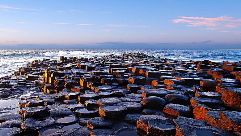
The northern edge of County Antrim does not welcome you; it confronts you. Over 40,000 interlocking basalt columns spill into the icy Celtic Sea—the aftermath of volcanic fissures erupting 60 million years ago. The wind here carries an unapologetic bite. For photographers, the golden hour is mandatory. The low evening sun casts dramatic shadows across the geometric stones, turning grey rock into honeyed amber.
Thermal protection is paramount. Source heavy, authentic Aran knitwear in the surrounding villages to combat the coastal chill. To anchor yourself calorically, secure a warm slice of local Barmbrack (traditional fruit tea loaf) or freshly fried dulse (seaweed) from a coastal vendor before descending.
- Immediate Topography: Dunluce Castle (a ruined medieval fortress perched perilously on a sheer basalt cliff, 10 minutes away) and Carrick-a-Rede Rope Bridge (a 20-metre suspension bridge historically used by salmon fishermen).
- Regional Satellites: Belfast City (96 km) provides crucial industrial and maritime history. Derry/Londonderry (65 km) remains one of Europe’s finest walled cities, essential for understanding the modern political fabric of Northern Ireland.
- Friction & Access Protocols: When utilising local Ulsterbus services or rural taxis, always confirm the final fare before departing. Meters are rarely engaged on coastal country roads. Emergency: Dial 999.
- Acoustic Sanctuaries: Escape the heavy foot traffic of the main columns by retreating to the secluded Port Na Spaniagh Bay via the Shepherd’s Steps. The sheer cliffs provide total acoustic buffering. Expect >15,000 steps on undulating stone; carry 1.5 litres of water in a thermal flask.
2. Maya Bay, Thailand

Maya Bay is a masterpiece of geological drama. This sheltered lagoon on Koh Phi Phi Leh is isolated from the Andaman Sea by 100-metre-high limestone karst. The air is thick with humidity and the aggressive acoustic echo of long-tail boat engines.
Following severe ecological degradation, the beach operates under draconian limits: swimming is strictly prohibited to protect recovering blacktip reef sharks. Shoot landscapes with a wide-angle lens (16-24mm) to capture the verticality of the enclosing cliffs. Carry a lightweight sarong for transit modesty, and purchase Khao Lam (sweet sticky rice roasted in bamboo) from pier vendors before boarding.
- Immediate Topography: Pileh Lagoon (an emerald-green inlet where swimming directly from boats is permitted) and Viking Cave (where locals harvest edible bird’s nests via precarious scaffolding).
- Regional Satellites: Ao Phang Nga National Park (80 km) features complex sea cave systems explorable only by kayak. Khao Sok National Park (180 km) shifts the focus from marine ecology to ancient terrestrial rainforest.
- Friction & Access Protocols: When negotiating private longtail boat operators in Ton Sai, finalize the exact duration, stops, and National Park fee inclusions upfront to prevent mid-journey extortion. Emergency: Dial 1155 (Tourist Police) / 1669 (Medical).
- Acoustic Sanctuaries: Because park rangers enforce strict time limits on the sand, your true sanctuary is the elevated wooden boardwalk built behind the beach. It offers heavy shade and a quiet vantage point over the interior jungle.
3. Navagio Beach, Greece
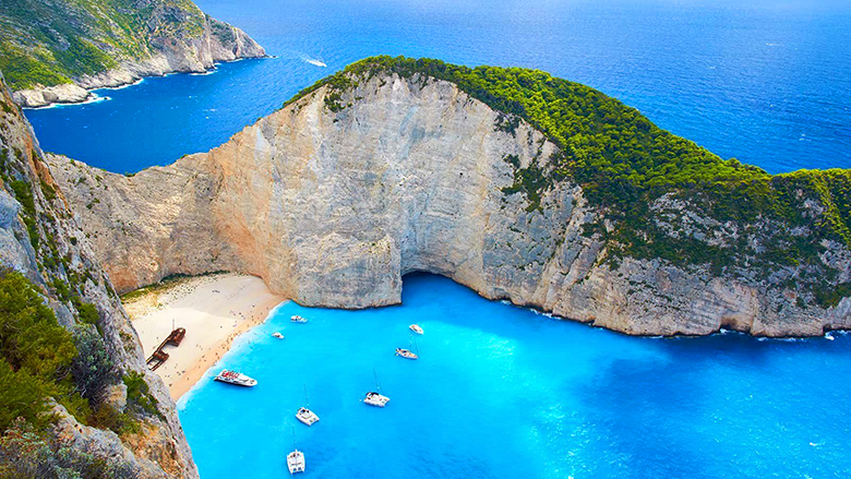
Navagio (Shipwreck Beach) on the Ionian island of Zakynthos is an arresting tableau of industrial decay meeting flawless Mediterranean topography. The rusted hull of the MV Panagiotis sits in stark contrast to the surrounding sheer limestone cliffs and the iridescent, milky-blue water.
The visual power of this cove is best captured from the vertiginous cliff-top viewing platform rather than the sand itself. Arrive before 09:00 with a wide-angle lens to secure the iconic top-down shot before the sheer walls cast deep, impenetrable shadows across the wreckage. Ditch fragile sandals for sturdy walking shoes if navigating the cliff trails. Before boarding a boat from Porto Vromi, secure fresh Loukoumades (fried dough drenched in honey and walnuts) to sustain you.
- Immediate Topography: The Blue Caves (a sequence of limestone sea arches where solar reflection turns submerged objects translucent blue) and Agios Georgios Krimnon Monastery (a 16th-century stone sanctuary).
- Regional Satellites: Kefalonia Island (30 km via sea) features an astonishing subterranean lake inside a collapsed cave. Ancient Olympia (100 km) is the birthplace of the Olympic Games, offering a massive injection of classical history.
- Friction & Access Protocols: If renting an ATV or scooter to reach the cliff-top viewpoint, test the brakes meticulously. The mountain roads are aggressively steep, slick with limestone dust, and frequently feature sheer drop-offs with no guardrails. Emergency: Dial 112 / 100 (Police).
- Acoustic Sanctuaries: The beach itself is often chaotic with tour boats. The inland village of Volimes, just a 20-minute drive from the cliffs, offers shaded, silent stone courtyards and traditional tavernas completely isolated from the coastal frenzy.
4. Anse Source d’Argent, La Digue, Seychelles
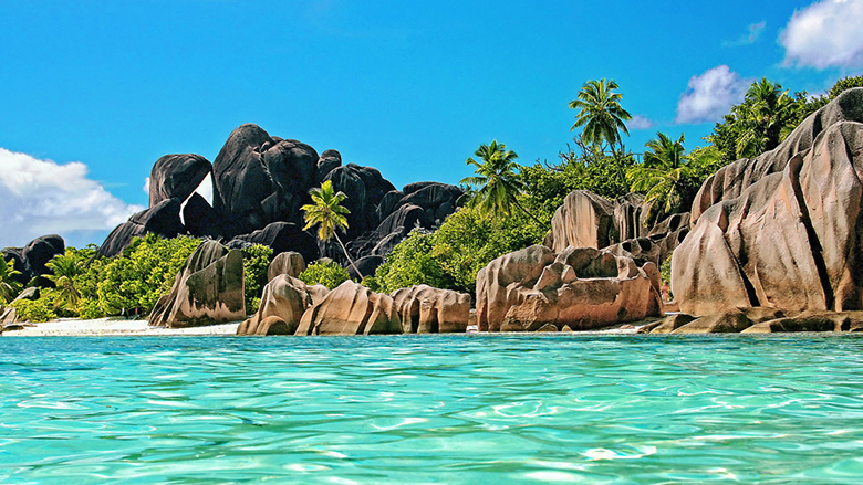
Anse Source d’Argent feels less like a beach and more like an architectural wonder of the gods. The shoreline is defined by colossal, prehistoric granite boulders glowing faintly pink against the impossibly clear Indian Ocean.
The water is bath-warm; the air smells of vanilla and drying copra. To photograph this space cleanly, you must arrive before 08:00, utilising soft, diffused morning light to capture the granite’s texture. Invest in locally crafted, cold-pressed coconut oil from L’Union Estate artisans. For a culinary anchor, seek out Ladob—plantains boiled in sweet coconut milk with nutmeg and vanilla.
- Immediate Topography: L’Union Estate (the historic vanilla and copra plantation you must traverse to access the beach) and Grand Anse (a wilder, wave-battered shore accessible by a jungle cycling path).
- Regional Satellites: Praslin Island / Vallée de Mai (15 km) houses the primaeval palm forest endemic to the Coco de Mer. Curieuse Island (20 km) operates as a protected bio-reserve dedicated to giant tortoise conservation.
- Friction & Access Protocols: Motorised vehicles are heavily restricted on La Digue. Rent a bicycle, but rigorously check the brakes and tyre pressure before accepting it; the sandy paths are treacherous.
- Emergency: Dial 999 (Police/Fire) / 151 (Medical).
- Acoustic Sanctuaries: When the beach’s narrow choke points become saturated at high tide, retreat to the shaded vanilla plantation pathways of L’Union Estate. The dense canopy instantly drops the ambient temperature.
5. Bioluminescent Beach, Vadhoo, Maldives
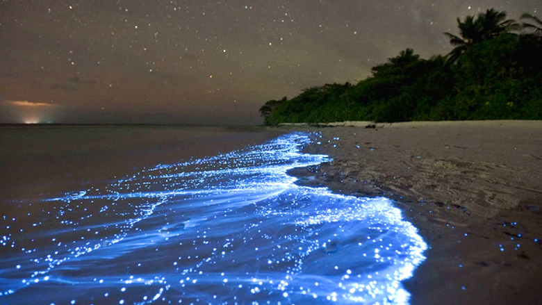
To stand on the shores of Vaadhoo at midnight is to witness the ocean mirroring the cosmos. This is a nocturnal theatre, driven by bioluminescent phytoplankton (Lingulodinium polyedrum) emitting cold, electric-blue light when agitated by the surf.
The air is heavy, humid, and scented with tropical dampness. Standard smartphone cameras will fail. You require a DSLR mounted on a tripod, with a wide-open aperture (f/2.8 or lower) and a slow shutter speed. Modesty is legally enforced on local (non-resort) islands; shoulders and knees must remain covered. Consume authentic Maldivian Bajiya (smoked tuna and coconut pastry) at a local teahouse before hitting the dark shores.
- Immediate Topography: Raa Atoll Coral Reefs (exceptional daytime snorkelling with manta rays) and the local Vaadhoo Village (offering a stark contrast to hyper-luxury resort bubbles).
- Regional Satellites: Malé City (190 km) exposes the administrative reality of an island nation facing rising sea levels. Hanifaru Bay (110 km) is the world’s premier location for mass manta ray feeding aggregations.
- Friction & Access Protocols: When booking private speedboat transfers after dark, verify the operator is fully licensed with functional GPS and running lights. Maritime navigation here relies heavily on localised knowledge.
- Emergency: Dial 119 (Police) / 102 (Ambulance).
- Acoustic Sanctuaries: The entire island operates as a quiet zone, but the inland palm groves offer a total sensory reset. The dense foliage shields you from coastal winds and provides grounding, silent darkness.
6. Shell Beach, Shark Bay, Western Australia
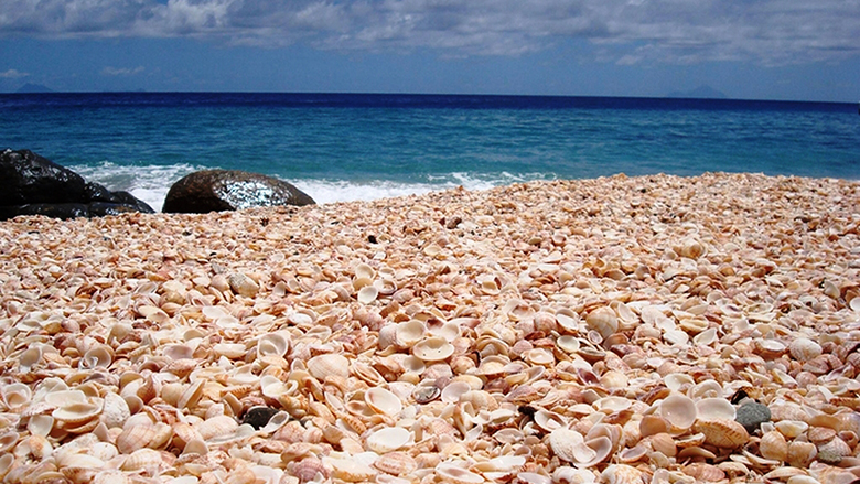
Located at the desolate, sun-scorched edge of the Australian continent, Shell Beach replaces traditional geological sand with an expanse of trillions of tiny, white bivalve shells. These stretch for over 60 kilometres and plunge 10 metres deep. The sheer salinity of the water allows you to float effortlessly, echoing the buoyancy of the Dead Sea.
The visual intensity of the white shells requires a macro lens to capture individual details, while a graduated ND filter will save wider landscape shots from complete overexposure. The shells can be razor-sharp; thick-soled, durable sandals are non-negotiable for navigating the shoreline. Stop at a local roadhouse in Denham to secure a classic Australian meat pie after enduring the coastal glare.
- Immediate Topography: Hamelin Pool Stromatolites (boardwalk access over living marine fossils—the oldest living organisms on Earth) and Eagle Bluff Boardwalk (a towering limestone cliff ideal for spotting dugongs).
- Regional Satellites: Monkey Mia (70 km) provides strictly regulated wild bottlenose dolphin interactions. Kalbarri National Park (350 km) offers staggering red sandstone sea cliffs and river gorges.
- Friction & Access Protocols: Driving at dawn or dusk in this region is a severe hazard due to massive kangaroo and emu populations crossing unlit highways. Strictly limit driving to daylight hours.
- Emergency: Dial 000.
- Acoustic Sanctuaries: Wade chest-deep into the hyper-saline water, lie back, and let the extreme buoyancy lift you. The sensory deprivation of floating here is an instant nervous system reset. This is a high-glare zone; carry a minimum of 2 litres of water per person.
7. Papakolea Beach, Ka-u’ Hawaii
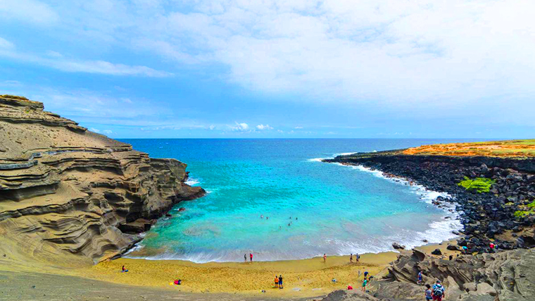
Reaching Papakolea requires surrendering to the raw, tectonic violence of Hawaii’s Big Island. Framed by a 49,000-year-old cinder cone that continuously erodes, the bay deposits heavy, silicate-rich olivine crystals onto the shore. The result is a surreal, verdant green coastline that feels entirely alien.
The three-hour, windswept hike across rutted volcanic pastureland demands physical respect. Photographically, wait for the mid-afternoon sun to illuminate the olivine crystals directly. Leave fragile footwear in the car; wear rigid, moisture-wicking hiking boots to handle the jagged descent. Pack a traditional Spam Musubi from a local mart in Naalehu; the dense salt and carbohydrates are perfect for the demanding trek.
- Immediate Topography: South Point / Ka Lae (the absolute southernmost tip of the US, featuring treacherous sea cliffs) and Punaluʻu Black Sand Beach (composed of crushed basalt, frequented by resting green sea turtles).
- Regional Satellites: Hawai’i Volcanoes National Park (65 km) is the epicentre of the island’s geothermal activity. Kealakekua Bay (75 km) offers the clearest snorkelling in the state within a marine life conservation district.
- Friction & Access Protocols: You will be aggressively approached by locals offering illegal, off-road 4×4 rides to the beach. Decline these services immediately. The heavy vehicles are actively destroying fragile burial grounds and coastal root systems.
- Emergency: Dial 911.
- Acoustic Sanctuaries: The arduous hike acts as a natural crowd filter. Finding a concave recess in the northern cinder wall provides instant relief from the relentless Pacific trade winds. This is a high-exposure zone with zero shade; 3 litres of water per person is mandatory.
8. Hidden Beach, Marieta Islands, Mexico
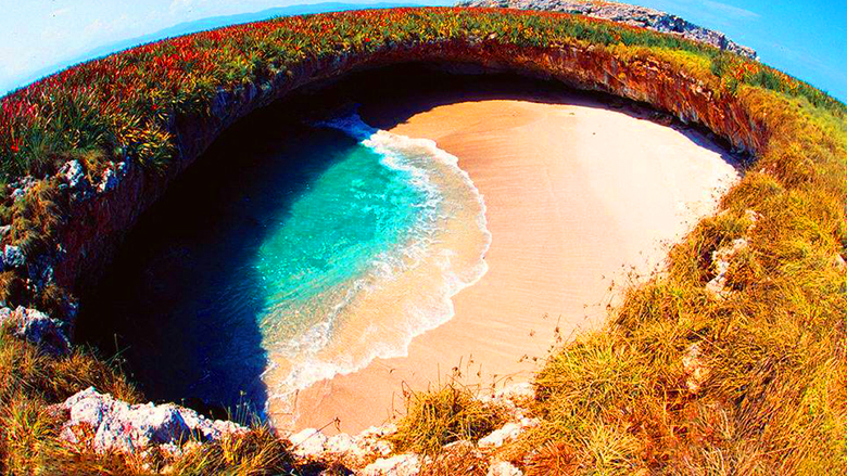
Playa del Amor is an architectural marvel of marine erosion and historical military testing. Located in the Islas Marietas National Park off the coast of Nayarit, it is a subterranean beach hidden entirely from the outside world. The air inside the cavern is noticeably cooler, echoing with the sound of water pushing through the tidal tunnel.
Because reaching the sand requires a mandatory swim through a rocky sea cave, leave the heavy DSLR gear behind. A waterproof action camera on a floating tether is the only viable tool. Environmental regulations are merciless; only organic, reef-safe sunscreen is legally permitted. Reward the physical exertion with a sharp, lime-cured ceviche tostada from a beachside palapa in Punta Mita upon return.
- Immediate Topography: Islas Marietas Bird Sanctuaries (a critical nesting ground for the rare blue-footed booby) and the Punta Mita Coastline (the ultra-luxurious launch peninsula).
- Regional Satellites: Sayulita (40 km) is a vibrant surf town offering boutique textiles. Puerto Vallarta (50 km) is a major cultural hub offering world-class gastronomy and the iconic Malecón boardwalk.
- Friction & Access Protocols: Access to the Hidden Beach is restricted to 116 people per day. Only book with operators that explicitly display valid SEMARNAT permits, or you will be turned away by marine park rangers at the tunnel entrance.
- Emergency: Dial 911.
- Acoustic Sanctuaries: Time inside the cavern is strictly limited (usually 20 minutes). Swim to the far edge of the sand, lie flat on your back, and look straight up through the natural oculus. The acoustics of the waves reverberating through the rock ring are profoundly grounding.
9. Seven Mile Beach, Grand Cayman Island, Caribbean
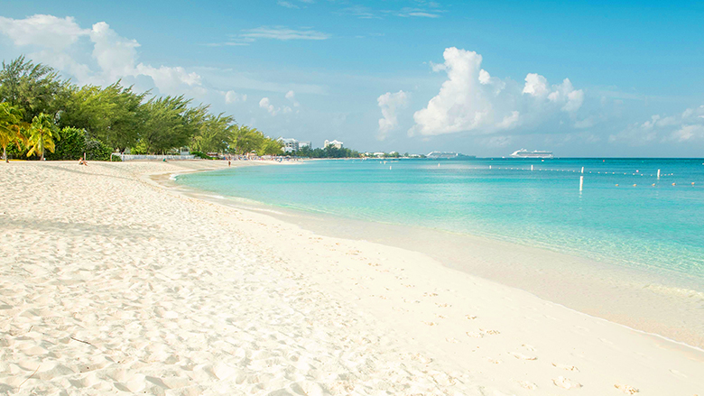
The western shore of Grand Cayman offers a masterclass in Caribbean equilibrium. Unlike the jagged, volcanic islands to the south, the topography here is relentlessly smooth. The water clarity is staggering, often exceeding 100 feet of visibility, smelling faintly of warm coral and salt.
To capture the vastness of the horizon, you need a circular polarising filter to pull deep cyans out of the water and cut the equatorial glare. Seek out authentic Caymanite stone jewellery, a rare, multi-layered dolostone unique to the island’s geological crust. Before surrendering to the beach chairs, find a local vendor serving heavy cake—a dense, spiced traditional dessert made from cassava and coconut milk.
- Immediate Topography: Camana Bay (a highly curated, pedestrian-friendly architectural enclave) and Governor’s Beach (a quieter stretch flanked by Casuarina trees).
- Regional Satellites: Stingray City (15 km) is a globally unique sandbar where wild Southern Stingrays congregate. Cayman Crystal Caves (35 km) is a subterranean network of ancient limestone dripping with stalactites.
- Friction & Access Protocols: Taxis on Grand Cayman are unmetered, and rates are set by the government. You must explicitly confirm whether the quoted fare is in Cayman Islands Dollars (CI$) or US Dollars (USD) before closing the car door to avoid severe exchange rate confusion.
- Emergency: Dial 911.
- Acoustic Sanctuaries: When the central stretch near the major resorts reaches sensory overload, retreat entirely to Cemetery Beach at the northernmost tip. The dense sea grape trees provide natural, isolating shade and a heavy acoustic buffer from the jet skis.
10. South Beach (Miami Beach), Florida, USA
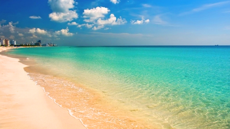
South Beach is a relentless, subtropical theatre where architectural preservation meets oceanic humidity. The barrier island is defined by the largest concentration of 1930s Art Deco architecture globally, framing a coastline that stretches into the turbulent Atlantic.
The air is heavily saturated, smelling intensely of coconut oil, Cuban espresso, and distant rainstorms. Photography requires a split approach: use a wide lens with a polariser by day, and a tripod for long exposures at night to capture bleeding neon. The brutal heat requires breathable, high-quality linen. Source a tailored Guayabera shirt from a Calle Ocho artisan, and secure an authentic, pressed Cubano sandwich before hitting the sand.
- Immediate Topography: The Art Deco Historic District (over 800 preserved pastel buildings featuring nautical motifs) and South Pointe Park (a landscaped tip offering panoramic views of cruise ships).
- Regional Satellites: Everglades National Park (75 km) is a sprawling sawgrass marsh ecosystem containing wild alligators. Key Largo (110 km) is the gateway to the Florida Keys, offering massive offshore snorkelling.
- Friction & Access Protocols: Ocean Drive and Collins Avenue are subject to punishing, unpredictable gridlock and extreme rideshare surge pricing. Rely entirely on walking, the free Miami Beach Trolley, or CitiBike rentals to navigate the grid.
- Emergency: Dial 911.
- Acoustic Sanctuaries: The sheer volume of bass-heavy music causes rapid exhaustion. Walk to the extreme southern end of the beach at South Pointe Pier. The structure extends over the water, replacing urban noise entirely with the sound of the Atlantic breaking against the pilings.
11. Pfeiffer Purple Sand Beach, California, USA
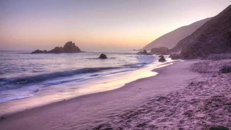
Hidden deep within the wild, cinematic stretch of Big Sur, Pfeiffer Beach is an elemental anomaly. The Pacific crashes violently against massive sea stacks, notably the Keyhole Arch. The shore bleeds purple—the direct result of manganese garnet particles washing down from the Santa Lucia Mountains.
The sensory profile is dominated by crushed redwood needles and salt spray. A polarising filter is mandatory to cut ocean glare and saturate the violet sand, which peaks in vibrancy after winter rainstorms. Dress in rugged, windproof layers. Bypass generic tourist traps for local Big Sur jade carvings, and secure a dense apple pastry from a coastal bakery before navigating the descent.
- Immediate Topography: McWay Falls (an 80-foot waterfall dropping directly onto untouched sand in Julia Pfeiffer Burns State Park) and Bixby Creek Bridge (Pacific Coast Highway’s most structurally elegant bridge).
- Regional Satellites: Carmel-by-the-Sea (50 km) offers a highly curated, refined culinary contrast. Monterey Bay Aquarium (60 km) provides unparalleled context to the complex kelp forest ecosystems offshore.
- Friction & Access Protocols: Cellular service is completely non-existent along this stretch of Highway 1. Download offline maps beforehand. Never leave valuables visible in your parked vehicle at the unmarked Sycamore Canyon Road turnout.
- Emergency: Dial 911.
- Acoustic Sanctuaries: Retreat to the northernmost edge of the beach, past the first barricade of boulders. The crowds thin out entirely, leaving only the hypnotic sound of Pacific wind funnelling through the sea caves.
12. Cayo Coco, Cuba

Separated from the Cuban mainland by a staggering 27-kilometre artificial causeway, Cayo Coco is a hyper-isolated ecological marvel in the Jardines del Rey archipelago. The air is thick with wild mangroves and salt. This landscape is defined by its delicate coral reefs and massive flocks of native pink flamingos.
A circular polarising filter is absolutely essential to cut the intense equatorial surface glare and capture the ethereal contrast of the white sand against the shallow water. Lean into authentic climate survival by packing breathable, locally tailored linen Guayabera shirts, allowing trade winds to cool the skin. Secure a traditional pastelito de guayaba (guava pastry) before leaving the mainland.
- Immediate Topography: Playa Pilar (featuring the highest sand dunes in the Caribbean, historically favoured by Hemingway) and El Bagá Nature Park (a protected coastal zone with endemic hutias).
- Regional Satellites: Trinidad (250 km) offers a perfectly preserved Spanish colonial settlement. Havana (500 km) serves as the essential urban anchor to understand the nation’s political and architectural history.
- Friction & Access Protocols: When navigating the keys, only utilise officially licensed “Cubataxi” vehicles. Negotiate and lock in the exact fare before the ignition turns over, as meters are frequently non-operational.
- Emergency: Dial 106 (Police) / 104 (Medical).
- Acoustic Sanctuaries: The western edge of the causeway offers secluded mangrove viewing platforms. Standing here at low tide removes you entirely from the resort acoustics, leaving only the sound of wading birds and shifting tides.
13. Santa Monica, California, USA
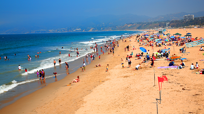
Santa Monica is where the sprawling, concrete velocity of Los Angeles collides with the Pacific Ocean. It is not a place of silence. It hums with the kinetic energy of volleyball games, crashing waves, and the metallic clatter of the historic wooden pier. The air carries a dense mixture of ocean brine, warm asphalt, and spun sugar.
For photographers, the golden hour here is absolute law. Use a fast prime lens (f/1.8) to capture long, moody shadows cast by the lifeguard towers. Embrace the Southern California uniform by layering with vintage, locally thrifted denim to combat the sharp temperature drop at dusk. Secure the legendary “Godmother” Italian sub from Bay Cities Italian Deli to ground yourself before hitting the sand.
- Immediate Topography: The Santa Monica Pier (featuring the historic 1922 carousel) and Palisades Park (a manicured, 26-acre park running along the sandstone bluffs).
- Regional Satellites: The Getty Villa (10 km) provides a staggering recreation of an ancient Roman country house. Malibu / El Matador State Beach (30 km) offers rugged sea stacks, stripping away the urban density.
- Friction & Access Protocols: Due to intense traffic, rideshare apps utilise heavily enforced, geo-fenced pickup zones around the beach. Do not attempt to hail a driver on the Pacific Coast Highway.
- Emergency: Dial 911.
- Acoustic Sanctuaries: Escape the relentless audio-visual assault of the pier by walking one mile north to the Annenberg Community Beach House. Its historic public courtyard offers structured architectural shade and a massive reduction in foot traffic.
14. Barceloneta Beach, Barcelona, Spain
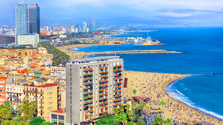
Barceloneta is an undeniable triumph of urban engineering. Meticulously revitalised for the 1992 Olympics, it now pulses as the coastal artery of Catalonia. The sensory profile here is aggressively cosmopolitan: the scent of saltwater tangles with frying garlic and the rhythmic thumping of beachside chiringuitos.
The transition from dense Gothic architecture to the open Mediterranean horizon requires photographic agility. Use a fast shutter speed to freeze the kinetic energy of kite surfers against the static skyline. Shift into the local sartorial rhythm by acquiring authentic, hand-stitched espardenyes (espadrilles) from the Gothic Quarter. Secure a paper cone of Bombas (spicy potato croquettes) to honour the area’s working-class fishing roots.
- Immediate Topography: Port Vell & The W Hotel (the striking architectural anchor of the coastline) and El Born / Gothic Quarter (a dense labyrinth of medieval streets).
- Regional Satellites: Montserrat (60 km) hosts a Benedictine monastery, providing a profound altitudinal escape. Sitges (40 km) offers cleaner coves and brilliant modernist architecture via a short train ride.
- Friction & Access Protocols: The sand at Barceloneta is a high-risk zone for highly skilled, organised pickpockets. Never, under any circumstances, leave your bags unattended when entering the water.
- Emergency: Dial 112.
- Acoustic Sanctuaries: When the beach density becomes suffocating, walk 15 minutes inland to the Parc de la Ciutadella. The heavy foliage, classical fountains, and sprawling lawns instantly filter out the coastal noise.
15. Harbour Island (Pink Sands Beach), Bahamas
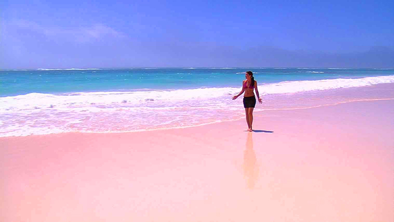
Harbour Island demands a recalibration of how you perceive colour. The Atlantic side of this three-mile-long island boasts sand tinted a distinct, elegant pink. This is the biological consequence of millions of crushed microscopic coral insects (foraminifera) mixing with white quartz.
The air is exceptionally pure, carrying only the scent of sea oats and tropical blooms. To accurately photograph this geological rarity without the sand washing out into white, you must shoot during the diffused light of early morning utilizing a macro lens. Support the local textile economy by wearing Bahamian Androsia batik fabric. Eat heavily spiced, deep-fried Conch Fritters paired with fierce local pepper sauce at a harbour-side shack.
- Immediate Topography: Dunmore Town (immaculately preserved, pastel-painted cottages draped in bougainvillea) and Lone Tree (a highly photographed, solitary piece of driftwood standing on the bay side).
- Regional Satellites: Eleuthera / Glass Window Bridge (15 km) is a dramatic strip of rock separating the churning Atlantic from the impossibly calm Bight of Eleuthera. Exuma / Pig Beach (200 km via air) offers highly interactive marine environments.
- Friction & Access Protocols: Cars are effectively useless here. The entire island navigates via electric golf carts. You must drive strictly on the left side of the narrow, unpaved roads in accordance with Bahamian law.
- Emergency: Dial 911 / 919.
- Acoustic Sanctuaries: The beach itself is rarely crowded, but the ultimate sanctuary is the secluded garden courtyard of The Dunmore hotel. Ordering a ginger-infused sparkling water here provides manicured silence away from the wind.
The world’s greatest beaches are far more than stretches of sand. They are living coastlines shaped by volcanic eruptions, shifting tides, coral reefs, relentless winds, and generations of local communities that continue to call them home. Each one demands a slightly different approach, rewarding travellers who arrive prepared rather than simply passing through.
Whether you’re navigating the basalt columns of Giant’s Causeway, waiting for the blue glow to appear on Vaadhoo’s shoreline, or watching the first light touch the granite boulders of Anse Source d’Argent, the most memorable moments rarely come from following the crowd. They come from understanding the landscape, choosing your timing carefully, and allowing the coast to reveal itself at its own pace. Long after the photographs are taken, it is the sound of the waves, the texture of the shoreline, and the feeling of standing at the edge of the world that stay with you.
Disclaimer: If you make a purchase with one of our links, we may earn a fee.